At ten years old in 1952, before the Salk vaccine, I contracted paralytic polio. Within two years I overcame the weakness in my limbs, but my back developed a slowly progressing, worrisome curvature. I tried to be active in sports, especially competitive swimming. Because the scoliosis was getting worse, I underwent major surgery in November of 1957 in which a bone sliver from my tibia was fused to my spine, I was in bed in a body cast with odorous stitches still in place until May of 1958, the remainder of my sophomore year. I then returned to the swimming team in my junior year.
In June of 1959, I had a reenforcing fusion from my other tibia, followed in August by refreshing two-mile swims in Maine’s Lake Megunticook to regain my strength. No cast after the second surgery but a stinky body brace which I wore to high school every day and only took off to attend the Senior Prom.
My love for the outdoors began in the summers in Maine where, starting in 1953, our family escaped summers in hot, noisy, dirty downtown Norristown, Pennsylvania. Working at summer camps in the Poconos reinforced my love for the freedom of the outdoors. In 1972, I hiked up Mt. Washington with my Gettysburg College roommate and his wife. It was the experience which began my love of hiking.
In 1973 after being out of work for a year in depressing Flint, Michigan, I got a teaching job at little Salisbury State College (SSC) in Maryland. It prospered and grew; in 1998, it became Salisbury State University (SSU) and in 2001 Salisbury University.
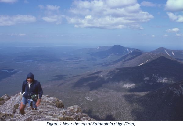
In the summer of 1975, with my brothers, Robbie and Tom, and my daughter, Shelley, I pulled off a badly prepared ascent of Mt. Katahdin, at 5,269 feet, the highest in Maine. The exhilaration was addictive.
In the seventies, I started doing circuit hikes in Shenandoah National Park. And in the early eighties, I became advisor of SSC’s Outdoor Club and began doing section hikes with its students on the Appalachian Trail (the AT) in the mid-Atlantic over weekends. For sections in southern Appalachia over spring breaks, and New Hampshire and Maine during summer vacations, I had regular experienced hiking partners on whom I depended for support, both physical and emotional. I had not yet committed to finishing my LASH (Long Ass Section Hike) but would do so over spring break of 1997 when I was given my trail name, Professor Hardcore.
By 1996, I was stubbornly hooked on AT hiking. Before my spring break hike that year, I had completed about 940 miles of the total AT. I still had over 1,200 to hike. I could not get any of my regular partners to accompany me to North Carolina. In my desperation, I cobbled together a group of students, all of whom, as it turned out, had zero-to-zilch long-distance hiking experience. As this hike was playing out, I referred to this group under my breath as the F— Ups (shortened to the FUs).
As a fifty-four-year-old, trail-obsessed English professor, here is my unlikely supporting cast of characters. Ken, a tall eccentric loner just into his forties, lived in a jerry-built wooden camper mounted akimbo on the bed of his pickup, often parked on campus. Scott H. in his late twenties was the most level-headed of the four though not very fit; he already had a slight paunch. I recruited Scott S., in his early twenties, from one of my Wilderness in Lit classes. From his undisciplined C- performance, I should have anticipated he would screw up. Finally, there was the freshman Joe with mildly erratic behavior shifts. I didn’t discover until after the hike that he was hypoglycemic. I christened Joe The Hypoglycemic Kid. All were somewhat incompatible, but Ken especially did not meld well with the younger three.
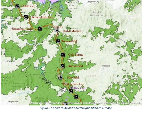
The plan for this hike was to go southbound from Stecoah Gap to the Nantahala Outdoor Center (NOC) on the Nantahala River near Wesser, North Carolina, and then continue northbound from Wallace Gap back up to the NOC for a total of 44.7 miles (see fig. 2). In elevation gained and lost, this is one of the most challenging sections of the whole AT. Its rugged Appalachian beauty is right below the Smokies, both geographically and aesthetically.
Someone should have warned the mountains that our group was on its way. Problems began on the van ride down. I should have taken the Chesapeake Bay Bridge-Tunnel to Norfolk, dropped down on I-85 to I-40, and driven the entire length of North Carolina to the NOC. Instead, eyeing the map distance as the crow flies, I opted to cross the Bay Bridge to Annapolis, go around DC, and then take I-81 past Johnson City, Tennessee—all the way to I-40, which goes east around the northern end of the Smokies at Davenport Gap. The last involves at least ten miles of switchbacks. The whole route, though it looked more direct, turned out to be several hours longer than driving across North Carolina. I was so anxious about the time that I ignored the majesty of the rock formations through which I-40 was carved.
Our entertainment on the way down was Ken’s instructional tape of bird calls. He was sitting right next to me with his headset on. I was at first interested in the music of natural sounds. The problem was that his earphones leaked about 30 decibels, and the scarlet tanager’s chirruping got to be intolerable after forty repetitions in twelve hours, especially when he was driving, and I was riding shotgun, trying to mark student papers.
Somewhere in Tennessee, Joe got a speeding ticket. Right after that we stopped at a gas station that had stale-looking, ready-made sandwiches in an unrefrigerated display case. Naturally, Scott S. bought one. A local would have known better. After a night at the NOC and a complicated shuttle, we finally got on the trail at Stecoah Gap, just below Brown Fork Gap Shelter.
We camped the first night with tents and a tarp at Locust Gap (above Sassafras Gap Shelter). Thanks to the well-aged gas station sandwich, Scott S. became nauseous. He let us know while vomiting five times that he was not long for this earthly life. I considered an evac, but that would have been difficult because a shuttle had dropped us off, and our van was at the NOC. In those days we had no cell phones. We would have had to hike the three miles back to Stecoah Gap and tried to flag a ride in the dark. By the next morning Scott had substantially recovered.
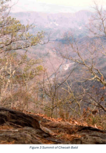
We started our hike with a slog up over Cheoah Bald, a major climb of almost 2,000 feet. I stopped at the summit to take a picture, so I should have been awed by the beauty of the vista framed by tree limbs. It is doubtful that I saw it. I was suffering from trail fever, a hikers’ term identifying those so intent on making mileage that they ignore the wonders of Nature through which they pass.
We still had to go down and up a second lower summit. Next came an epic descent into the NOC, down more than 3000 feet in eight miles. The Hypoglycemic Kid and Scott S. were not far behind me at the summit of Cheoah Bald. But after the summit, these two fell well back. The Kid was doing peanut butter (evidently to help his condition) but then unwittingly left the group’s PB&J food bag in the middle of the trail. Ken. and Scott H. were well behind all three of us. They limped into the NOC three hours after me, almost in the dark, moaning woefully.
We had a reservation in a bunkhouse catawampus on a steep hill. Ken and Scott H. had picked up the PB&J bag.
Ken said, “We found this bag on the trail and had to carry it back. It was heavy and added to our weight.”
Scott H. agreed, “For sure, it slowed us down.”
“Yes, it definitely slowed us down,” Ken said.
The bag weighed all of four pounds, but they were serious.
So far, we had completed 14.3 miles. The next day we were to do a big shuttle down to Wallace Gap, where our group was to start hiking thirty miles northbound back to the NOC. After a night in the bunk house filled with moaning and whining, the three FUs had reached an unspoken consensus. Still lying in their bunks, they finally verbalized it.
“I don’t want to hike any more. I am in deep pain,” Ken said.
“For sure, I’m not hiking again,” added Scott H.
Scott S. sighed and moaned.
“I’ve eaten almost all the PB&J. Count me out,” said Joe.
After their performance on the two previous days, I was happy to accede. With such an inexperienced group, I should have anticipated their bailing. I had repressed that the sections we were attempting were indeed challenging.
My fallback proposal was for the FUs to shuttle me to Wallace Gap on Route 64. They would then meet me later that day in the SSU van at Wayah Gap (north of Rock Gap Shelter on the map).
With my pack only lightly loaded, I cruised solo that 9-mile northbound section, passed on the way by a faster-moving Brit thru-hiker who cheerioed me on. When I got to Wayah Gap, I settled down to wait for the FUs, reclining sleepily in the grass by the side of the road in the sun. During my pleasant snooze, a solicitous park ranger pulled over and warned me about a big snowstorm on its way. Still half asleep, I nodded to him. But the nod did not mean our group would drive right down off the mountain. I still had hiking “on my mind,” sort of like “woman” in the Gary Puckett song.1)Gary Puckett and the Union Gap song — https://www.youtube.com/watch?v=nEdzv_Q6-ls
When the four finally arrived in the van, we set up camp in a rhododendron grove not too far from the road. It got very cold during the night and towards morning it began to snow. Ken had an Outdoor Club sleeping bag that had a broken zipper.
Regularly every half hour, he announced, “I’m freeezing.” And each time the “eee”s got longer. Toasty in my winter-weight bag, I tried to ignore Ken. Around 3 a.m., I felt guilty enough about not checking his bag beforehand that I lent him some of my spare warm clothing.
The next morning, despite increasing cold and snow, I announced I would continue my AT hike northbound. I would climb the 4.2 miles up to the summit of Wayah Bald. There was a road up to the summit which intersected the AT numerous times. Accompanied by the Kid, I started obsessively up the trail. My mood was as gray and tortured as the tree I photographed.
To make sure the Kid and I were OK, I had the van with Scott H., Scott S and Ken wait for us at the intersections. Toward the top, we got off the trail and walked the road.
This gallery is not published.Near the summit were an old stone ranger cabin and outbuilding—a rustic scene bleached gray by the snow. When we got to the summit, we all climbed the observation tower. There was not yet much snow on the ground, but the wind cut through my parka as if it were “Mack the Knife,” sharp but no sign of blood.
For too long a time, I contemplated trying to go on in the snow and get picked up at the end of that day by the others. It was good that I did not. The students may not have been able to drive the van up the snowy, windy roads to one of the high gaps. Persistence in the face of the hostile Appalachian wild is admirable, but suicide is not.
As we started our long drive down off the mountain, the students, who at this point had much more sense than I, affirmed my agonized decision to pause my hike. From Wallace Gap to Wayah Bald, I had done an additional 13.2 miles to add to the 14.3 done earlier for a depressing total of 27.5.
We drove the van down the fourteen miles of the sharply twisting road to Franklin, North Carolina, and got motel rooms. As the park ranger had warned, this late March storm became a major one. Once it got going, it would dump over two feet of snow at higher elevations. Since the trail was covered with snow and most all the northbounders had gotten off, I finally gave up the idea of continuing my hike. For spring break 1996, there would be no more of my torturous AT obsession; my interaction with the FUs was still unwinding.
Scott H., Scott S., and The Kid got inexpensive rooms in a hostel, but I found a more upscale motel room that I invited Ken to share with me. I was buddying up with the bird-call man, because I wanted to be in a more comfortable bed. Segregating myself from three of the FUs, I was beginning to realize I was one of them.
That night over pizza and the next morning over breakfast, I floated a plan to drive down to Georgia and go white water rafting on section IV of the Chattooga River. This had been my ambition ever since I had read James Dickey’s book Deliverance (1970) and had seen the movie (1972), parts of which were filmed on that river.2)Information about the movie Deliverance — https://www.imdb.com/title/tt0068473/
Driving down to Georgia, I began to feel closer to the FUs. We stopped at an information center and discovered the existence of Tallulah Gorge State Park. Below where we would raft, the Tallulah River, with its scenic gorge and waterfall, intersects the Chattooga to form Lake Tugaloo. Our group hiked down a steep trail into the bottom of the gorge. We saw boulders with striations and flatter rocks in which whirlpools left conical wells.
Some of the rocks had a granular texture, often colored with long grains parallel to each other.
This gallery is not published.Refreshed by this geologically fascinating side quest, we headed off to the NOC Outpost near Clayton to get ready for the Chattooga. I was in high anxiety over this and had already died many times before we finally got on the bus to the river.
On our way to Clayton, I had been saying to myself how relatively civilized the people we met in the environs of the Chattooga looked. I was thinking in contrast to some of the characters in the “sleepy and hookwormy” town of Oree at the beginning of Deliverance. There was the old farmer with the “spotted hands trembling as if he were deliberately making them do it” (the one whom Burt Reynolds first asks for a shuttle).3)James Dickey, Deliverance (New York: Dell, 1970) 51. And who can forget the Griner brothers, the good ol’ boy garage owners who finally agree to do the shuttle? And even more gothic, Lonnie, the inbred albino banjo player of “Dueling Banjos” fame?4)Dickey 54, 57. I was OK with my “relatively civilized” until we stopped at Micky D’s, and I spotted the figure behind the counter. He appeared to be a close cousin of Lonnie. I expected to see him waving his banjo at us as our raft crossed under the Route 76 bridge. I was now mortally afraid and was convinced I would be responsible for all our deaths. Around forty paddlers have died on the Chattooga since the 1970s after Deliverance was published.
There were four of us in our raft, not including our guide. It turned out she was Cathy Kennedy, the daughter of NOC founder, Payson Kennedy. He had been Ned Beatty’s double in the Deliverance film. She got us through all the very difficult rapids very well, but on the biggest, she did not quite get her rudder placement right.
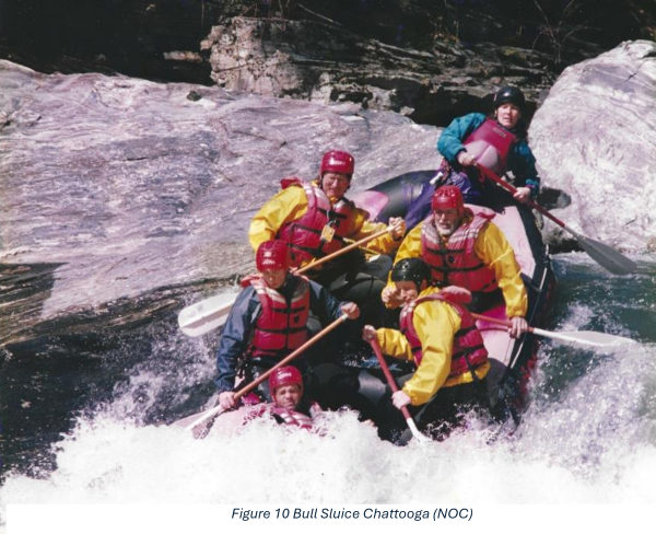
As the picture shows, we all stayed in the boat, though I had stopped paddling. Note that none of us, even Cathy Kennedy, had paddles in the water. Scott S. in the front is lucky he did not get washed overboard. As uncoordinated as the picture shows us, we happily finished the Chattooga much more together as a group. On the flat-water paddle below the rapids, the sun was a Georgia peach which kissed us with its hospitality. A heavenly breeze blew away the cruel mountain men stereotypes from Deliverance in my head.
On the way home, we drove back up to the NOC for one last lunch at the river restaurant. We heard stories there from northbounders of one crazed hiker who had kept plodding through the snow. Even so, our group made the right decision (though I did have to come back on spring break 2001 to complete the section from Wayah Bald north to the NOC). My obsessive trail fever, the FU’s inexperience, and Appalachian spring snow spoiled our hike. But while rafting the Chattooga, our group achieved a deliverance from the cold and our incompatibility. We may not have hiked well together, but in the end, all the FUs, me included, were in the same boat.
Born in 1942, William C. Horne is a twenty-eight-year completed section hiker of the Appalachian Trail. After contracting polio as a ten-year-old, he developed a spinal curvature which progressed to 110 degrees by the time he completed the AT in 2003. Directly after, he was fused with titanium rods. He has hiked in the Rockies (north, central, and south) and canoed, kayaked, and cross-country skied in Canada and Alaska.
A Faculty Emeritus at Salisbury University in Maryland (1973-2009), he has been married to Susan since 1963, has two children and four granddaughters. His four-volume autobiography is available on Amazon. For more information about the writer, visit his website: https://www.professorhardcore.com/.
*Images in the body of this writing were provided courtesy of William C. Horne and are his property.
**Featured image credit: Taylor from Unsplash